From Phoenix to Rocky Point and Playa Encanto: (212 miles, +/- 4 hour trip)
Click Here to Load PDF version
Click Here to Load PDF of Space Shot
Travel west on I-10 from Phoenix towards California.
Exit on State Route 85, heading south towards Gila Bend. Gila Bend is a great place to gas up, if necessary, and have lunch at Subway @ the Chevron Station, Burger King, McDonalds or Taco Bell @ Love's Gas Station.
Toward the west end of Gila Bend, turn right just before McDonalds. This exit is marked with a sign stating "Mexico" and "SR-85 South".
Continue south on SR-85 to Ajo. Ajo is a great place to stock up on groceries you may have forgotten at the Olsen's-IGA Market, which is just north of the Texaco Gas Station on the right side of the street. Ajo is about the same size as Gila Bend. There are a number of banks with ATM's and it is also the best place to purchase your Mexican Automobile insurance. Many visitors choose to gas up and purchase their Mexican Insurance at the Holt Texaco Station. You will want to purchase insurance for every full day of your anticipated visit in Rocky Point.
Continuing south on SR-85 out of Ajo, the next "civilization" is Why, Arizona. Any fueling or insurance missed in Ajo, can be purchased at the Chevron Station in Why.
Continue South through the beautiful Organ Pipe National Monument, all the way to the border at Lukeville, Arizona. The settlement at Lukeville is also called "Gringo Pass". It is the last stop prior to the border crossing into Mexico. Additional facilities; gas, groceries, etc., are also available, should you choose.
When you reach the border, pay attention to the red and green lights at the entrance to the border crossing. A green light and a friendly wave from the Mexican border officer, means that no stop is necessary...keep on cruising to Rocky Point. A red light and a flagging from a Mexican border officer will ask you to pull off to your left and stop for a brief moment. They may ask you for your trunk to be opened and confirm that you are not importing any goods into their country that you should not be. Please be polite and cooperative, as this process rarely takes longer that a minute or so. The border officers are generally very pleasant people. A word of caution: IT IS ILLEGAL AND YOU WOULD BE ILL-ADVISED TO BRING FIREARMS OR AMMUNITION INTO MEXICO. DO NOT DO IT! Puerto Peñasco (Rocky Point) is located in the Mexican Free Zone. This means that you will not need a passport or visa to visit this town or the surrounding resort areas. There is no fee to cross the border.
Once over the border, you are immediately entering the border town of Sonoyta. Continue South approximately 1.8 miles from the border and you will come to a three-way intersection. Stay to the left towards Pto. Peñasco/Santa Ana; do not go West toward San Luis. Approximately 1 block South of the three-way intersection, and over the Rio Sonoita Bridge, the road will again split into a Y. Stay to the right, and you will be on the road to Rocky Point. This is Mex Rt. 8/Pto. Peñasco. You will pass "Vasquez's" on your left, if you have made the correct turn. There is a traffic light soon after Vasquez's that is easy to miss if you don't pay attention. Driving in Mexico is not a problem, as long as you drive defensively. The speed limit is listed in kilometers and is fairly slow through the town, so take note.
See below how to bypass downtown!!
Continue along the same road, all the way to Rocky Point. Sonoyta to Puerto Peñasco: The two-lane asphalt highway is well maintained for the full 62 miles to Rocky Point. This is Mexico Route 8. It is although in an open range area. Therefore, on occasion, there may be livestock on or near the highway. Once in Rocky Point, follow the local signage or other directions to your destination. Mex Route 8 going South into the town of Rocky Point becomes Blvd. Juarez. Many of the major hotels are listed on the overhead signage.
DOWNTOWN BYPASS!!
Please note this convenient route for homeowners or their visitors staying in these resort areas: Playa Encanto, Playa La Jolla, and Playa Miramar. Approximately 53 miles from the border, and 50 minutes, there is a new and convenient highway which bypasses Rocky Point and leads straight to the residential communities listed above. Exit right and then left at the Caborca turn-off. The overhead signage will direct your way. Head East towards Caborca 7.3 miles to the old Caborca Hwy. If you are heading to Playa Encanto or Playa La Jolla, turn right going West to the Playa La Jolla sign, which is 1 mile, and turn left heading South onto the unpaved road. Follow this road 4.5 miles, turn right and follow the appropriate signage for your intended destination.
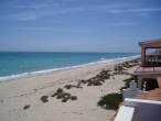
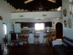
Look for sign for Playa Encanto. You will pass on the left Paradise Villas. You will enter through the guard gate. Continue to our House. It has been recently painted and the color is different than the color shown in the pictures.
|